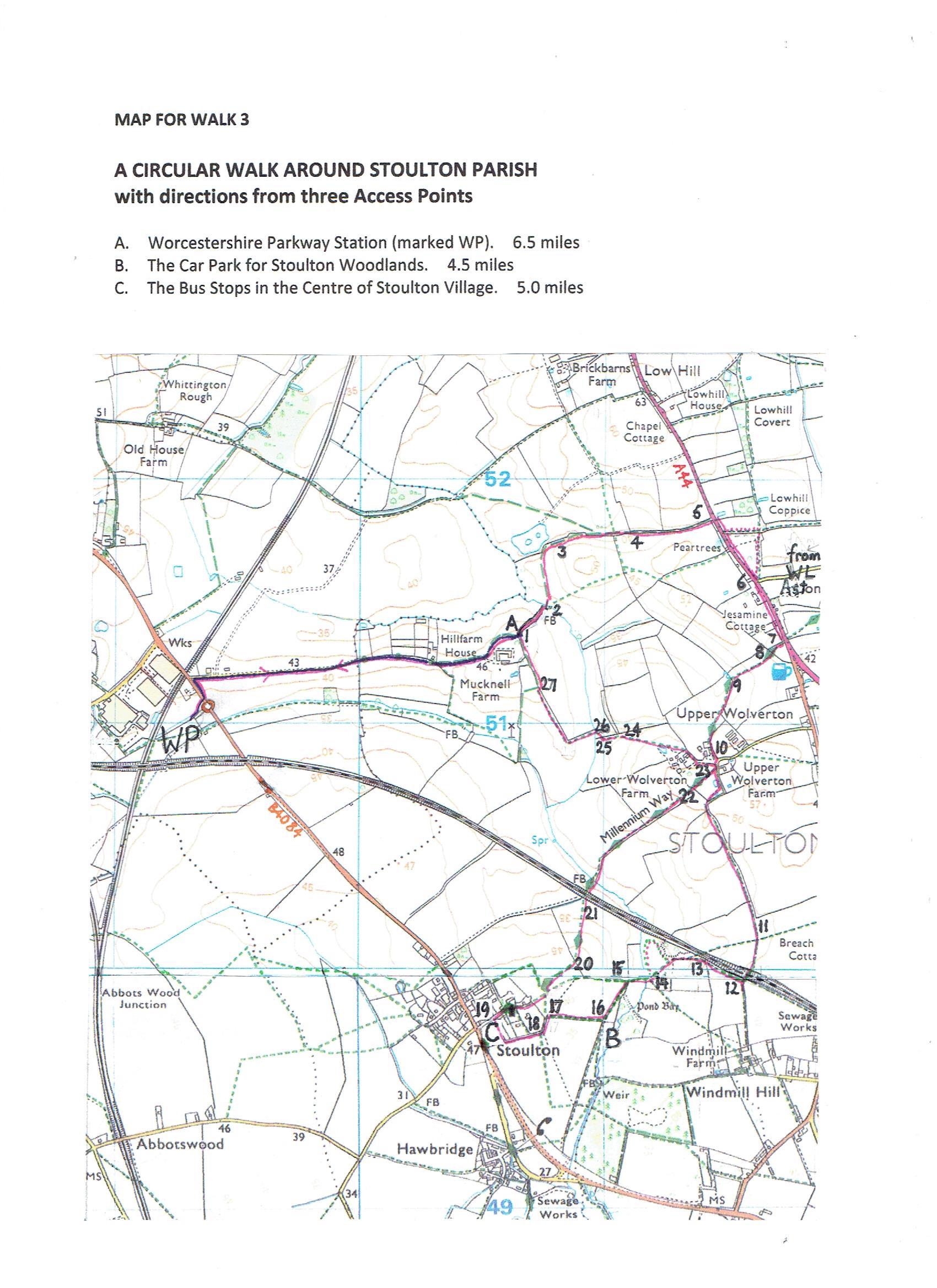
CIRCULAR WALK 3. A circular walk around Stoulton Parish
A circular walk with three Access Points.
A. Worcestershire Parkway Railway Station (marked WP). 6.5 miles.
B. The Car Park for Stoulton Woodland. 4.5miles.
C. X50. Bus stops in the centre of Stoulton Village. 5 miles
Follow the walker’s instructions. Each instruction will take you to a point numbered on this map.
WALKER’S INSTRUCTIONS.
Each instruction will take you to at point numbered on the map.
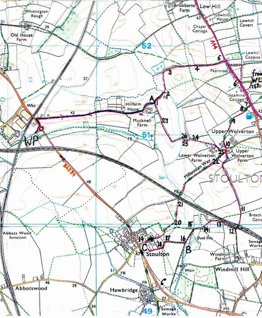
Starting from Worcestershire Parkway Station. It is approximately one mile from the station to Access Point A. Walk from the station to the roundabout on the B4084, cross the road and turn left towards Worcester (do not follow the footpath sign). Turn right into Mucknell Farm Lane just before the railway bridge. Walk along the lane towards Mucknell Abbey (marked Mucknell Farm on the map). At its end, bypass or cross the cattle grid and follow the bridleway signs that skirt the Abbey to its left. Ignore all crossing paths (which belong to the Abbey) and continue to walk gently uphill until you reach a five-barred gate leading into the corner of a large field. You have now arrived at Access Point A on the map, ready to start the circular walk.
1. Go through the gate and continue walking in the same direction, heading down the field (which at times can be muddy and overgrown) keeping the hedge on your left-hand side. At the bottom take the footbridge over the stream. (Point 2.)
2. After the bridge keep walking for a few more yards until you reach a broad grassy track. Don’t continue diagonally up the hill but turn left here, onto the broad track. (Point 3)
3. Follow this clear, wide, track as it sweeps round the field passing some trees and up the hill. Eventually you will have the hedge on your left and a mound on your right. (Point 4).
4. Veer to the left as you leave this field, and keep going.You will see a blue bridle way waymark on a post ahead of you. Keep going in the same direction with the hedge on your right, along a track which becomes a narrower path in the corner of the field (in the summer when the grass is high it’s hard to see), passing between some trees, and then some buildings on your left, until you meet the busy A44. (Point 5.)
5. Cross the road, turn right, and walk along the grass verge beside the busy road. After about 100 yards, you could take the option to go through the gate on your left and follow the footpath across a field, turning right as it meets another footpath. However, there are often cattle grazing in these fields, and you might prefer to continue along the side of the road for this short distance. Continue until you pass (or meet) the turning from White Ladies Aston. (Point 6.)
6. Cross back over the road as this part of the verge becomes much wider and makes easier walking. Find a footpath on your right just past the last cottage, Jasmine Cottage.( Point 7)
7. Go through the gate and keep walking straight ahead with the paddock fence on your left. Go through the gate at the far side and cross the foot-bridge. (Point 8.)
8. Keep going in the same direction, following the path that leads across the the field ahead of you. At the far side of this field go through a gap in the hedge ahead of you. (Point 9.)
9. Turn immediately left, and walk up the side of the field, keeping the hedge on your left, as the path sweeps to the right. Keep as far to the right as you can and head towards the buildings coming out into a lane by ‘Kit’s Kitchen’. (Point10.)
10. Turn left here. At the T junction take the bridle way directly ahead of you. Follow the track around the edge of the orchard, round a right-hand bend and continue to follow the path as it turns left when it meets the field, known locally as ‘Stoney Furlong’. Here the track becomes grass covered. Follow this path, alongside the field, keeping the hedge on your left and the field to your right. If you are walking in springtime you should be able to hear skylarks singing above this field. The path also gives you excellent views of the countryside around. (Point 11.)
11. Continue along this path, and at the edge of the hedge on your left, pass a large ash tree, head slightly right on a narrower path, across an open field until it takes you over the railway at the far side of the field. (Point 12.)
12. Go through the gate on the other side of the bridge, and immediately turn right. Walk down here, parallel with the railway, and step over the low fence at the bottom. (Point 13.)
13. When you are level with the footpath that crosses the railway from your right, turn left and cross the field diagonally to your right. This path, not clearly marked, leads from the oak tree to the gap in the hedge on the other side of the field. (If walking across here is difficult depending on time of year, crops, and occasional electric fencing, keep walking round the edge of the field, staying close to the railway till you reach the bottom of the hill and carry on round till you come to the gap in the hedge mentioned above). (Point 14)
14. Cross the next field (sometimes you may have to walk between a double row of horse fences) and cross the footbridge on the far side. (Point 15)
15. Immediately turn left and follow the edge of the field, keeping the ditch on your left hand side. In the very corner of the field is a well-hidden metal kissing gate leading into a plantation. (Point 16)
You have now reached Access Point B on the map.
(Coming from the car park to Stoulton Woodland take the right-hand footpath through the metal gate and follow the track straight to reach Access Point B.)
16. Don’t go into the woodland but turn right here and head up the hill towards the village of Stoulton. (Point 17)
17. Ignore the field entrance to your left at the top of the hill, but take the next left, along a broad path, known as Parker’s Lane. (Point 18)
18. Follow this green lane all the way to the end where it meets Church Lane. Turn right here. )Point 19.)
You have now reached Access Point C on the map.
(Coming by the X50 bus from Worcester or Pershore alight in the centre of Stoulton Village and walk forward (back from Pershore) on the B4084 to the crossroads. Follow the signpost to the church along Church Lane as far as the junction with the green lane on your right and Manor Farm on your left to reach is Access Point C.
19. Explore Church Lane and view the historic houses. Visit the 900 year old Church of St. Edmund where you will be able to find information about the long history of the church and the village. Leave the village with the Old Vicarage on your left and continue along the rough road leading to a gateway and footpath with then leads into a field. Carry on in the same direction straight across to the other side. From this path you will be able to have a good view of Bredon Hill to your right. At the far side of the field, turn left, and walk towards a way marked post (which may be invisible at first if the crop has grown high). (Point 20.)
20. At the post, turn to your right and follow the path diagonally down the hill towards the railway bridge. This railway is the mainline from London to Hereford. Pass under the bridge, through the gate, and across the next field. A wooden footbridge (previously a traditional stone, hump-backed, packhorse bridge) will now take you across the stream. If you look under the wooden bridge, you should be able to see the old stone supports for the previous bridge. (Point 21.)
21. Carry straight on, following the grassy track on the side of the field, keeping the hedge on your right, heading towards a line of poplars at the top, (which you will only be able to see when you have gone round the first right-handed bend). From this point, if you look to your left, you can see Mucknell Abbey and behind it a wind turbine, this belongs to the owner of the land beyond the Abbey. When you reach the top of the field, you should be able to have a lovely view across the countryside towards the Malvern Hills. Looking back you can also see Stoulton Church from this vantage point. (Point 22.)
22. At the top of this field is a way mark pointing straight ahead. Follow this rather indistinct way, between rows of trees, to the opposite side of the apple orchard, where you will meet a gravelly (and sometimes muddy) track. (Point 23.)
23. Turn left here, and left again after about 30 yards. Walk along this lane, with a farm on your left-hand side. Don’t be put off if the gate is closed across the lane; it is there to put off motorists, not walkers, and you are on a public right of way. As you follow the track through the field ahead of you look out for the path that leads diagonally to your left across the field between the crops. Take this path and cross the field as it threads down to the far side. (Point 24)
24. At the far side, you will meet a broad grassy track. Turn left here and continue walking down the side of the field to the bottom. Point 25.
25. Look out for the track that leaves the field in the bottom corner. Turn right here. (Point 26.)
26. After about 50 yards, turn left over a footbridge and along a very narrow path that leads through vegetation into the next field. Keep walking in the same direction, keeping the hedge on your right-hand side, and following the edge of the field as it turns a sharp right-angled bend to the right. Keep walking up the side of the field. Ahead of you is Mucknell Abbey. It is also possible to spot hares in this field. Find the gap on your right at the far end. (Point 27.)
27. Go through the gap and continue walking in the same direction, this time with the hedge of your left-hand side. When you arrive at the corner of the field, you have reached Access Point A. (Point 1.)
Back to Worcestershire Parkway Station. If you began the circular route here, go through the gate to your left, and follow the bridle way, and beyond that the lane leads back to the B4084 and the approach to Worcestershire Parkway Station.
Download your own copy of the Map and the Walker's Instructions here.