
STOULTON VILLAGE: Properties in Church Lane. (once called Church Street)
INTRODUCTION. The Gables, Stoulton Village Hall - once the Village School, Stable Cottage - part of the farmstead of Stoulton Farm, Manor Farm House - the old farmhouse, Briar House - built on land of the farmhouse.
The Old Vicarage - generations of Stoulton parsons lived here. The Stables - once the housed the vicar's coach and horses, but it is now now a self contained apartment. The HayLoft - now a holiday rental it is no longer used to store the hay for the horses, The Tynings - a single house now but once the home of the Sexton and the early 19th century village school. Manor Bank - built on Joseph's Orchard. St Edmund's Church built early 12th century. The Garth, once called Church Garth and Kirkfield were built on land once owned by the owners of the Malthouse.Kirkfiled, a bungalow was built as the new Vicarage in 1957/8. It was built on Malthouse land. Malthouse- once a farm house with malthouse, now a private home. The Campanile- appears on early maps The Lodge -appears on the 1634 map, Thornbank once of the first infill properties. The Long House built in the 1970s on the old carrot patch belonging to The Mount. The Brew House a converted building that once belonged to The Mount, now Mount Pleasant, Mount Pleasant House once known as The Mount and before that The Somers Arms and The Talbot! The main entrance was once on the Pershore Road.
About Church Lane
Church Lane and Wadborough Road once made a
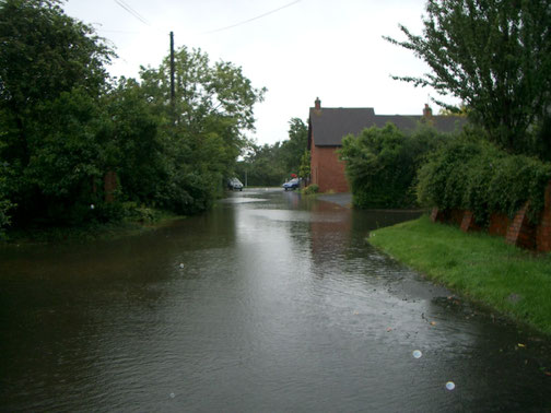
T- junction with the road to Worcester.There was no road down the steep bank to Hawbridge. It is possible to imagine this if you look carefully at this picture taken in 2007. Until the building of the 'High Road' in the 19th century these roads would have been ancient 'holloways' made by generations of people, carts and animals travelling east - west. Today the slope from Church Lane to the High Road is quite steep.

This image looks down Church Lane towards Wadborough Road. In the foreground is the roof of the old malting house. Barley was a significant crop in Stoulton for centuries. In the Domesday Book Stoulton, Mucknell and Wolverton were described as berewicks of the Bishop of Worcester's Manor of Kempsey - berewicks are also considered by some to be 'barley farms'.
Look at the shape of the houses on the left hand side of the lane, they have plenty of stories to tell. The roof immediately obvious on the left of the picture belongs to the house currently known as the Malt House. This property was once the village malting house.
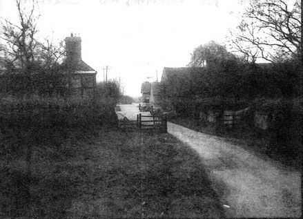
On the right is Stoulton Farm (once called Stoulton Court Farm) and its farm buildings. Right at the end of the lane, past the old school are the stables that once to the Somer's Arms when it was a Coaching Inn. This picture must have been taken from the Church Tower, the next picture, taken at ground level shows how the Church and its land, the Vicarage and the Glebe land and Vicarage Cottage were once gated off from the rest of the lane.
This would have changed by 1958/9 when the Vicarage and Vicarage Cottages were sold. The then vicar, the Reverend Trevor Morgan, was instrumental in purchasing land from the owners of the Malt House and building a new bungalow as a Vicarage. This did not prove appropriate and it too was sold. Currently (2022) the Rectory is in Manor Farm.
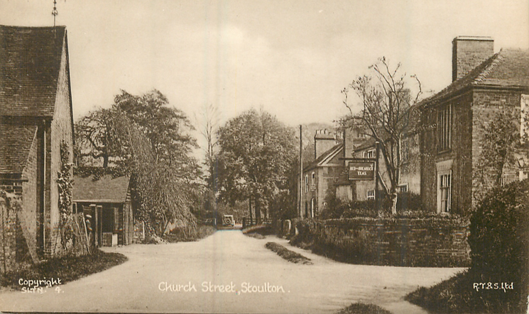
In 1937 the Church, the Vicarage and Vicarage Cottages stood behind a gate at the head of the street. The Malthouse on the right was both a malting house and the village post office. Stoulton farm was a working farm and according to this postcard The Lodge was the place to go to for a cup of tea! Sadly the village had lost the daily chatter of children on their way to the village school, it had closed in 1932/3 today the children go to school in Drakes Broughton and then on to Pershore High School.
In the archives of the Stoulton Estate, held a Eastnor Castle in Herefordshire, there are references to the buildings and activities of the Stoulton community going back to the 17th century and earlier. Of particular interest to Church Lane is a plan of the Stoulton Estate dated to 1634, it shows properties standing on the same platforms as many of the properties still to be seen in the lane today. We have no idea whether these are the actual houses we suspect that may be.